The North Anchor Stone Is Found
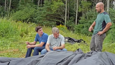
On Oak Island’s northern shore, Marty Lagina and Alex Lagina join Jack Begley, Gary Drayton, and surveyor Steve Guptill to search for a second “anchor stone” — a feature theorist Erin Helton believes is marked on a 14th-century French map.
After trekking along the so-called Boulderless Beach, the team reaches a large boulder that matches the size and general character of the first anchor stone they identified. Steve points out a marking near the top — something that resembles a “T” or a cross.
Alex isn’t convinced it’s deliberate, but admits the shape is intriguing, especially because it faintly echoes the famous “boat stone” markings in Massachusetts.


A Mark That Raises an Old Templar Theory Again
The discovery instantly pulls the discussion back toward the long-running “boat stone” theory — a boulder in Westford, Massachusetts that some believe carries 14th-century carvings, including a ship and other symbols.
Years earlier, theorist Robert Markus argued the boat stone inscriptions were the beginning of a treasure map leading to Oak Island, tied to the alleged voyage of Scottish Templar Knight Henry Sinclair.
So the question becomes unavoidable: if this northern boulder truly is an “anchor” reference point, could the marking — natural or carved — be part of the same symbolic language used to guide someone toward a hidden destination?
Erin Helton’s Triangulation: Money Pit Within Feet
Back in the war room, Erin Helton lays out what she calls the strongest part of her theory: independent data sources lining up.
She presents a 1939 Popular Science map of Oak Island that marks multiple boulders and measurements. Erin explains that by combining these “anchor” points with other boulder references, she can triangulate a specific location for the Money Pit.
She draws alignments between mapped boulders — including one near the swamp and another along the coastline — then adds a circular measurement based on the West Anchor. The intersection of these lines produces a target point.
When she compares that point to the team’s chosen caisson center — the best modern representation of the Money Pit area — her proposed location lands within roughly three feet.
For the room, that’s not a fun coincidence. That’s a precision hit.
“Lock in the Anchors”: The Team Moves to Confirm
The Laginas agree that if Erin’s anchor stones can be confirmed with exact survey data, it strengthens everything that follows — including her promise that the same geometry could help predict the vault’s true position.
They ask Steve to lock in the West and North anchor coordinates and provide Erin the measurements she needs. The logic is simple: the smaller and more clearly defined the anchor points are, the more precise the downstream alignments become.

Zena Halpern’s Documents: A Map, a Cipher, and a New Timeline
Another layer of intrigue arrives through historian Doug Crowell and Knights Templar researcher Zena Halpern, who shares two maps and a cipher.
One map appears to reference Nova Scotia, including a possible link to New Ross, an area some believe connects to Henry Sinclair. More startling is the French Oak Island map itself: it includes labeled features that seem to match the island’s known geography — references that appear to align with the swamp, marshland, and a “dam” location tied to prior discoveries.
Even more provocative: the map suggests activity as early as 1347, implying a possible presence centuries earlier than the Sinclair narrative.
But among the familiar references are unfamiliar labels: anchors, a valve, and a hatch — terms that don’t neatly match anything the team has documented.
That is exactly why the team wants to pursue it.
The “Hatch” Search Area: Jack Overlays the French Map
Using satellite imagery, Jack Begley attempts to overlay the old French map onto modern geography. Despite the obvious limitations — erosion, scaling drift, and centuries of landscape change — the coastline alignment is close enough to identify a workable search zone.
The “hatch” indicator lands in a general area near Dave Blankenship’s property — and Dave says he has already noticed a strange ground depression there.
Close enough becomes actionable.

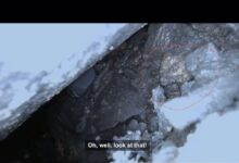
A Square, Man-Made Opening in the Ground
When the team reaches the site, they find something that doesn’t look natural: a square-shaped opening with evidence of removed rock and loose fill.
Archaeologist Laird Niven examines it and quickly concludes it appears cut in, not formed naturally. The structure looks defined on multiple sides, with at least one side showing signs that it may continue outward.
The immediate hope is obvious: a tunnel entrance, a back door, or a controlled access point — something consistent with an engineered underground system.
The Hard Part: Permits and Authorities
The team’s next move isn’t cinematic, but it matters.
Laird explains that an investigation of this type requires proper permitting — even hand tools aren’t a loophole. The group agrees to disclose the feature to the authorities and pursue permits before any excavation.
It will cost time, but it protects the work — and protects the credibility of whatever the hatch turns out to be.
What This Sets Up Next
By the end of this stretch, Oak Island’s story shifts into a new configuration:
- Two “anchor stones” now appear to be confirmed targets tied to Erin Helton’s map-based geometry
- Erin’s triangulation places the Money Pit area within feet of the team’s existing work
- Zena Halpern’s documents introduce new labels that the team hasn’t explained before
- And the “hatch” — now physically located — could represent an entirely new access point, pending permits
If these pieces connect the way the team suspects, the hunt may be moving from theory to coordinates… and from coordinates to an entrance.